Evacuation Map & Guide
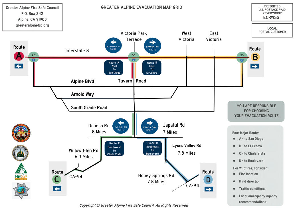
The Greater Alpine Fire Safe Council along with the Alpine Fire Department, the San Diego Sheriff's Department and critical support from Supervisor Dianne Jacob created the first comprehensive wildfire evacuation plan in San Diego County.
The plan has two major components. The first identifies for major routes out of Alpine. Each route has a “Trail Head Sign” indicating route name and direction. Within the Alpine Fire District, each route intersection is tagged with the blue evacuation sign and a directional arrow.
The second component is a simplified and easy-to-follow map of the major exit routes. The reverse side provides important information detailing how to track a wildfire in real-time, how to choose the best evacuation route, what to take with you, and what needs to be done to your home prior to an evacuation.

Resources for choosing your Evacuation Route:
➝ Firemap.sdsc.edu for the location of the fire and wind direction in the vicinity of the fire. Here’s a video tutorial:
➝ Flightradar24.com for the location and state of the air attack
Close Notifications [if any]
Select Widgets: Statistics, Tweets (Close any other widgets offered)
note whether the center of the Fire Captain’s circular track around the fire moves toward or away from your location to determine the direction of fire
➝ Firms2.modaps.eosdis.nasa.gov other near-real-time satellite info. Here’s a video tutorial:
➝ Google.com/maps/ for the traffic conditions on each of your possible routes.
Select Directions By car [arrow to the right of Search Box)
Enter Starting Address
Select any intermediate locations needed to specify the Evacuation Route
Add Final Address
Check for traffic on All Possible Routes
Recommendations from local emergency agencies.
Make your route choice carefully and evacuate immediately when ordered!